

Toronto, Canada – TheNewswire – July 13, 2022 – Mammoth Resources Corp. (TSXV:MTH), (OTC:MMMRF), (the “Company”, or “Mammoth”) is pleased to provide results from an additional four drill holes from its diamond drilling program at its 100% owned Tenoriba gold-silver property located in the prolific Sierra Madre precious metal belt, Mexico.
The drill program is designed to test up to five target zones which measure from hundreds of metres (m) to over one kilometre (km) in strike length along a 4 km, east-west trend of gold-silver mineralization identified in 3-dimensional (3D) modelling incorporating data from over 3,000 soil, chip and channel samples, 26 prior diamond drill holes, geological and structural mapping and the potential continuity at depth of surface mineralization as indicated by an Induced Polarization/Magnetometer (IP/Mag) geophysical survey (please refer to the descriptions of target zones in the press release dated July 22, 2021).
An additional four diamond drill holes have been completed for a total of 320.7 m bringing the total reported to date to 2,234.6 m in 17 holes. Refer to Figure 1 – Location Map, Tenoriba Property Drilling, 2021-22 (drill holes TEN 21-01 to 21-27). A summary of potentially economical intervals from the four drill holes from this press release are as follows.
|
Hole |
Weighted Average Gold |
Weighted Average Silver |
Weighted Average Copper |
Weighted Average Gold Equivalent* |
||||
|
Location |
Number |
From |
To |
Total |
Grade |
Grade |
Grade |
Grade |
|
(m) |
(m) |
(m) |
(g/t) |
(g/t) |
(%) |
(g/t) |
||
|
Moreno |
TEN 21-14 |
0.0 |
9.0 |
9.0 |
0.32 |
5.6 |
0.40 |
|
|
TEN 21-15 |
24.0 |
54.0 |
30.0 |
0.52 |
8.4 |
0.63 |
||
|
(including) |
46.5 |
51.0 |
6.0 |
0.85 |
12.5 |
1.02 |
||
|
(including) |
37.5 |
40.5 |
3.0 |
0.86 |
26.3 |
1.21 |
||
|
TEN 21-16 |
0.0 |
12.0 |
12.0 |
0.60 |
0.7 |
0.61 |
||
|
(and) |
24.0 |
102.2 |
85.7 |
0.44 |
2.3 |
0.47 |
||
|
(including) |
24.0 |
30.0 |
6.0 |
0.92 |
3.1 |
0.97 |
||
|
TEN 21-17 |
0.0 |
33.0 |
33.0 |
0.60 |
2.8 |
0.64 |
||
|
(including) |
0.0 |
9.0 |
9.0 |
1.06 |
1.2 |
1.07
|
Thomas Atkins, President and CEO of Mammoth commented on the most recent drill results, stating: "We keep intersecting some impressive intervals in our drilling. Both extensive interval lengths, as evidenced by nearly 90 metres grading almost 0.5 grams per tonne gold equivalent in gold and silver in hole TEN 21-16 in the Carneritos area, plus some higher-grade intersections of over a gram per tonne gold equivalent over shorter interval lengths, in these and other holes among those reported in this press release. The interval lengths, gold grades and taking into account they’re intersecting predominantly oxidized rock over large target areas, these characteristics all continue to favour a bulk, open pit mining and heap leach gold extraction operation, which is what we’d hoped for from this drilling.
“The success of this drilling is enabling Mammoth to block off areas hundreds of metres up to over a kilometre in size via significant step-outs from sparce historical drilling. Grades in this drilling are comparable to multi-million ounce deposits currently being mined or under development by major mining companies in the same district as Mammoth’s Tenoriba project, in Mexico. Even though we’re often drilling with step-outs of up to a couple of hundred to as much as 700 metres from any prior drilling, we’re intersecting potentially economical open pit, heap leach, gold-silver mineralization, occasionally with copper, in almost 90 percent of the holes we’re drilling; an exceptional success rate.
“The drill contractor concluded drilling activities at Tenoriba in late April and core was logged and samples shipped for analysis following this period. There’s been a hiatus in reporting drill results. Results have been arriving from the lab, however as our small field team was equally focused on completing the logging and sampling of core while coordinating the demobilization of camp and equipment as the project area enters the rainy season, the team taking some well deserved rest after 8 months in the field, plus the entire corporate team occupied on the annual corporate audit, these activities and results arriving from the lab have led to some delays in this reporting and we hope to be reporting on the remaining ten drill holes from the recent drill program in the coming weeks.”
Richard Simpson, Mammoth’s Vice President Exploration further commented on these results, stating: “With these results, drilling has returned to the large Carneritos area where we previously only had drilled a total of seven drill holes. Hole TEN 21-16, in particular, illustrate the continued potential in this large target area wherein we intersected potentially economical gold-silver mineralization over almost 90 metres."
“Mammoth geologists are particularly excited by the mineral potential at Carneritos. The High Sulphidation target area at Carneritos is similar, if not larger than that hosting million ounce plus reserves at the Mulatos, La India and El Sauzal mines in the same Sierra Madre belt as Mammoth’s Tenoriba project.
“Abundant surface gold-silver mineralization occurs within a large 1,400 metre long by at least 400 metre wide area typified by advanced argillic altered outcrops of dacite porphyry and associated breccias with alteration assemblages of kaolinite, abundant dickite, silica and vuggy silica. These altered volcanic rocks coincide with a geophysical magnetic low. The mag low is believed to be the result of the destruction of magnetic minerals by intense mineralizing hydrothermal fluids, the same fluids responsible for the alteration assemblages. These combined features are common within High Sulphidation altered volcanic rocks, typical of a collapsed volcanic dome."
The drill results from this release compliment drill intervals from the following ten previously released drill holes.
|
Hole |
Weighted Average Gold |
Weighted Average Silver |
Weighted Average Copper |
Weighted Average Gold Equivalent* |
||||
|
Location |
Number |
From |
To |
Total |
Grade |
Grade |
Grade |
Grade |
|
(m) |
(m) |
(m) |
(g/t) |
(g/t) |
(%) |
(g/t) |
||
|
Carneritos |
TEN 21-01 |
7.5 |
45.0 |
37.5 |
0.31 |
17.1 |
0.53 |
|
|
(including) |
36.0 |
40.5 |
4.5 |
0.47 |
75.2 |
1.47 |
||
|
TEN 21-02 |
No significant values
|
|||||||
|
TEN 21-03 |
0.0 |
43.5 |
43.5 |
0.54 |
3.6 |
0.59 |
||
|
(including) |
19.5 |
25.5 |
6.0 |
0.69 |
2.7 |
0.73 |
||
|
(including) |
30.0 |
34.5 |
4.5 |
0.67 |
4.6 |
0.73 |
||
|
TEN 21-04 |
0.0 |
19.5 |
19.5 |
0.53 |
7.3 |
0.63 |
||
|
Masuparia |
TEN 21-05 |
12.0 |
28.5 |
16.5 |
0.27 |
4.6 |
0.34 |
|
|
172.5 |
195.0 |
22.5 |
0.22 |
3.0 |
0.26 |
|||
|
TEN 21-06 |
0.0 |
18.0 |
18.0 |
1.21 |
1.5 |
1.23 |
||
|
(including) |
16.5 |
18.0 |
1.5 |
6.46 |
2.8 |
6.50 |
||
|
27.0 |
49.5 |
22.5 |
0.57 |
0.6 |
0.58 |
|||
|
TEN 21-07 |
94.5 |
102.0 |
7.5 |
0.23 |
5.2 |
0.30 |
||
|
133.5 |
135.0 |
4.5 |
0.23 |
2.6 |
0.26 |
|||
|
TEN 21-08 |
60.0 |
73.5 |
13.5 |
0.30 |
6.4 |
0.40 |
||
|
103.5 |
111.0 |
7.5 |
0.22 |
1.3 |
0.24 |
|||
|
Masuparia |
TEN 21-09 |
No significant values
|
||||||
|
Moreno |
TEN 21-10 |
15.1 |
18.1 |
3.0 |
– |
0.6 |
0.14 |
0.25 |
|
74.6 |
88.1 |
13.5 |
0.09 |
4.1 |
0.15 |
|||
|
(including) |
86.6 |
88.1 |
1.5 |
– |
– |
0.20 |
0.33 |
|
|
TEN 21-11 |
1.5 |
7.5 |
6.0 |
0.20 |
3.0 |
0.25 |
||
|
27.0 |
42.0 |
15.0 |
0.34 |
2.1 |
0.37 |
|||
|
(including) |
36.0 |
42.0 |
6.0 |
0.59 |
2.9 |
0.63 |
||
|
Carneritos |
TEN 21-12 |
4.5 |
51.0 |
46.5 |
0.45 |
5.1 |
0.51 |
|
|
Moreno |
TEN 21-13 |
0.0 |
37.5 |
37.5 |
0.98 |
15.1 |
1.18 |
|
|
(including) |
10.5 |
28.5 |
18.0 |
1.13 |
21.4 |
0.55 |
2.34
|
|
|
49.5 |
61.5 |
12.0 |
0.08 |
0.4 |
0.45 |
0.65
|
||
Notes: Gold Equivalent where silver grade is converted to gold grade at 75 g/t silver = 1 g/t gold = 13.0 lbs copper.
Mammoth attempts to drill as near perpendicular as believed to be the orientation of mineralized control features, however drill set-up location options can challenge this objective. Intervals shown are core lengths versus perpendicular, true widths of these mineralized features.
Drill Hole Description:
Mammoth has initially drilled 2 to 4 holes at significant, up to 250 m drill spacings, within each target area then moved to another target area to drill a similar number of holes (please refer to press release dated July 22, 2021 for target zones). Company geologists were waiting the results from the initial 2 to 4 drill holes in a target area prior to returning to the area to follow up drilling of these areas based on the results from the initial holes. Where mineralized intervals are intersected in the initial sequence of drilling, or where holes fail to encounter mineralization as suggested by the data, any follow up drilling will be based on field assessments combined with surface geology, sampling and geophysics data to assist in defining additional drill collar locations with the aim of assisting in more clearly understanding and testing the controls and continuity to gold-silver mineralization.
Hole TEN 21-14 was collared in the Moreno target area with the objective of testing a similar Carneritos-like epithermal High Sulphidation (HS) precious metal mineralized system and a high resistivity feature identified in the 3D geophysical modelling which coincides on surface to the mapped altered volcanic breccia. Holes TEN 21-15 through TEN 21-17 were collared in the Carneritos target area where abundant surface gold-silver mineralization occurs within a large 1,400 metre long by at least 400 metre wide area typified by advanced argillic altered outcrops of dacite porphyry and associated breccias with alteration assemblages of kaolinite, abundant dickite, silica and vuggy silica. These altered volcanic rocks coincide with a geophysical magnetic low. The magnetic low is believed to be the result of the destruction of magnetic minerals by intense mineralizing hydrothermal fluids, the same fluids responsible for the alteration assemblages. These combined features are common within High Sulphidation (HS) altered volcanic rocks, typical of a collapsed volcanic dome.
Drill Hole TEN 21-14
The hole was collared in the Moreno target area, over a similar Carneritos-like epithermal HS precious metal mineralized system. The hole was drilled to a depth of 67.1 m of a planned 100.0 m at 70 degrees decline/dip, azimuth 90 degrees and was collared approximately 130 m west-northwest of hole TEN 21-11, 107 m northwest of hole TEN 21-13 and 105 m southeast of historic hole TEN 17-03.
The hole was drilled to test the altered and mineralized epithermal dacite porphyry dome present at the Moreno target area. It was testing a shallow high resistivity anomaly identified by the 3D geophysical modelling and an associated low magnetic anomaly which both coincides on surface with the altered outcropping silica and dickite containing volcanic breccia. Drill hole TEN 21-11 returned two significant gold Eq intervals, including 6.0 m grading 0.25 g/t gold Eq and 15.0 m grading 0.37 g/t gold Eq. Hole TEN 21-03 returned 43.5 m grading 0.59 g/t gold Eq. Hole TEN 21-13 intercepted 37.5 m grading 1.18 g/t gold Eq.
The first 9.0 m of hole TEN 21-14 was highly weathered and contained alternating oxide and non-oxidized intervals of moderately silicified volcanic breccia with dickite infilling irregular fractures, followed toa depth of 48.5 m by generally weakly silicified and locally minor irregular black sulfide filling fractures in lithic volcanic tuff. From 48.5 m to the bottom of the hole at 67.1 m moderately to strongly silicified dacitic feldspar phyric unit is present with 5 to 7% disseminated pyrite and 2 to 3% black sulfide stringers. In the last 1.1 m the core cut highly broken material indicative of having cut a fault which resulted in the drill rods sticking and the core barrel was lost. Aside from the losses due to the drill rods being lost to the fault, the hole was a success in identifying the source of the resistivity anomaly, although the mineralized interval in this particular hole was lower grade. The silica/dickite alteration present along the hole explains the targeted high resistivity anomaly. The area appears to be affected by late faults and needs further modeling and drilling to evaluate the impact of the faulting in the area.
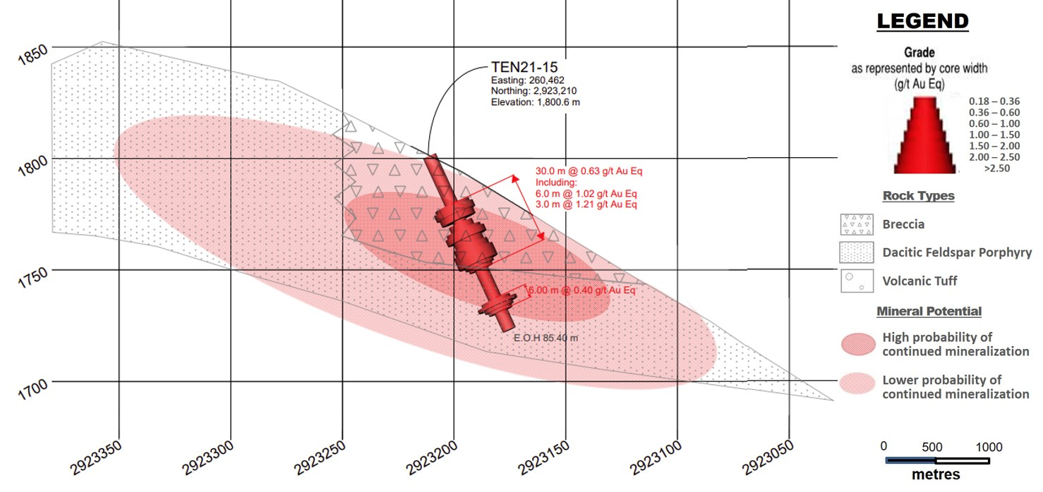
Drill Hole TEN 21-15
The hole was collared in the epithermal HS gold-silver mineralized system in the Carneritos area. The hole was drilled to a depth of 84.4 m of a planned 100 m at 65 degrees decline/dip, azimuth 185 degrees and was collared approximately 135 m west-southwest of hole TEN21-04.
Hole TEN 21-15 was drilled to expand the southwestern boundary of the mapped area of the HS mineralizing system at Carneritos over altered and mineralized outcrops/sub-crops of dacitic volcanic breccia on surface and a combined low IP geophysical resistivity and chargeability features with low magnetic features identified from the 2021 infill geophysics survey. The target also coincides with numerous anomalous gold in soil and rock chip samples and the nearest hole TEN21-04 returned 19.5 m grading 0.63 g/t gold equivalent (Eq).
The first 64.4 m of hole TEN 21-15 is generally highly oxidized and frequently highly fractured. The first 53.65 m, where the core is preserved is weakly to moderately silicified volcanic breccia followed by weakly silicified and argillized dacitic feldspar phyric unit to the end of the hole at 85.40 m of which the interval from 58.50 to 64.40 m is highly oxidized. Refer to Figure 2 – Drill Section, Drill Hole TEN 21-15 (looking east). Potential exists for additional mineralization at depth to the east-southeast of hole TEN 21-15 where rocks typical of the area are mapped and elevated gold in soil values occur. Drilling in 50 to 100 m step-outs to the east-southeast of hole TEN 21-15 is recommended with the objective of continuing to test the southwest limit of the Carneritos target area.
Drill Hole TEN 21-16
The hole was collared in the epithermal HS gold-silver mineralized system in the Carneritos area. The hole was drilled to a depth of 102.2 m of a planned 100 m at 70 degrees decline/dip, azimuth 360 degrees and was collared approximately 45 m northeast of hole TEN21-03 and 175 m east-northeast of hole TEN21-04.
Similar to hole TEN 21-15, hole TEN 21-16 was drilled to expand the depth potential of the mapped outcrops/sub-crops of dacitic volcanic breccia on surface of the HS mineralizing system at Carneritos, which combine with low IP geophysical resistive and chargeable features and low magnetic features identified from the 2021 infill geophysics survey. The target also coincides with numerous anomalous gold in soil and rock chip samples and holes TEN 21-03 and TEN 21-04 which returned 43.5 m grading 0.59 g/t gold Eq and 19.5 m grading 0.63 g/t gold Eq, respectively.
The hole intercepted a dacitic porphyry unit and associated variably altered/weathered breccia from surface to the bottom of the hole. The first 44.05 m is weathered and oxidized. From 44.05 to 94.15 m the unit is predominantly brecciated, generally having undergone moderate silica alteration interspersed with short intervals of increased to strong silica alteration. From 94.15 m the silica alteration is weak to non-existent. Refer to Figure 3 – Drill Section, Drill Hole TEN 21-16 (looking east)
The hole was a successful in intersecting the low resistivity, low chargeability feature observed in the 3D geophysics modelling. This feature coincides with the weathered, oxidized dacite porphyry down to 44.05 m core depth which is variably mineralized from surface to the bottom of the hole. Drilling in 50 to 100 m step-outs to the north of hole TEN 21-16 is recommended with the objective of continuing to test the northern limit of the Carneritos target area and in particular a 110 m north step out where vuggy silica float returned 0.64 g/t gold and 10.2 g/t silver.
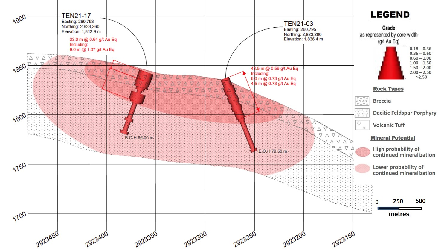
Drill Hole TEN 21-17
The hole was collared in the epithermal HS gold-silver mineralized system in the Carneritos area with the aim of testing mineralization at depth, including a geophysical resistivity anomaly at depths of as much as 250 m. The hole was drilled to a depth of 66.0 m of a planned 250 m at 80 degrees decline/dip, azimuth 360 degrees. The hole was collared approximately 80 m north of hole TEN 21-03 and 70 m northeast of hole TEN 21-16. The hole failed to reach its targeted depth of 250 m due to poor ground conditions and the risk of losing drill rods due to their tightening within this poor ground.
The hole was drilled to test continuity of mineralization at depth of altered mineralized dacitic porphyry – breccias present on surface and testing a buried sub-vertical resistive feature identified by the 3D geophysical modelling. Neighbouring holes TEN 21-03 returned 43.5 m grading 0.59 g/t gold Eq and hole TEN 21-16 returned 12.0 m grading 0.81 g/t gold Eq plus 85.0 m grading 0.47 g/t gold Eq, including 3.7 m grading 1.57 g/t gold Eq.
From surface to 16.3 m hole TEN 21-17 intercepted highly weathered argillized and oxidized lithic tuff, followed by the dacite feldspar porphyritic unit until the end of the hole at 66.0 m. From 45.8 to 60.2 m the core is highly argillized and oxidized with weak silica and/or dickite. Despite not reaching its intended depth, the hole was a success in that it intercepted 33.0 m of potentially economical gold-silver mineralization in altered dacitic porphyry with style of mineralization and alteration consistent with the Carneritos HS volcanic dome target. The hole failed to reach the deeper resistivity anomaly which was part of the drill target and as such this feature remains to be tested. Follow up drilling should include an approximate 120 m northeast step out of hole TEN 21-17 to continuing to test the northeast limit of the Carneritos target area and fill the approximate 190 m gap between hole TEN 21-17 and TEN 21-12 along this northeast orientation where a moderately to locally, highly silicified breccia outcrop zone returned numerous rock chip samples grading above 1.0 g/t gold, the best of which assayed 6.41 g/t gold and 24 g/t silver over 1.0 m.
Qualified Person / Quality Controls:
Richard Simpson, P.Geo., Vice-President Exploration for Mammoth Resources Corp. is Mammoth’s Qualified Person, according to National Instrument 43-101 for the Tenoriba property and is responsible for and has reviewed any technical data mentioned in this news release.
Samples referenced in this press release were prepared and analyzed by ALS laboratories (ALS) in their facilities in Mexico and Canada, respectively. Samples generally consisted of a minimum of 2 kilograms of material. Drill core is mostly HQ diameter core with minor lengths of NQ diameter core. Core is sawn in half with a rock saw with one half used for sample analysis purposes. Where samples are taken these are most often 1.5 metres in length, only in poor recovery sections do they exceed this length, with rare exceptions exceeding a maximum of 4.5 metres in length. Samples are collected with sample ticket and deposited into plastic sample bags sealed with nylon zip lock ties, then loaded into grain sacs similarly sealed with a nylon zip lock tie prior to transport by Mammoth personnel to ALS’s facility in Chihuahua, Mexico for sample preparation. Gold and silver analyses are performed in ALS’s facility in Canada via a 30-gram fire assay with an atomic absorption finish. Silver, copper, lead and zinc are analyzed as part of a multi-element ICP package using a 4-acid digestion. Any over limit samples with greater than one percent copper, lead and zinc are re-analyzed using ore grade detection limits. Blank and duplicate samples are inserted randomly at approximately every 15 samples.
About Mammoth Resources:
Mammoth Resources (TSX-V: MTH) is a precious metal mineral exploration Company focused on acquiring and defining precious metal resources in Mexico and other attractive mining friendly jurisdictions in the Americas. The Company holds a 100% interest (subject to a 2% net smelter royalty purchasable anytime within two years from commencement of commercial production for US$1.5 million) in the 5,333-hectare Tenoriba gold property located in the Sierra Madre Precious Metal Belt in southwestern Chihuahua State, Mexico. Mammoth is seeking other opportunities to option exploration projects in the Americas on properties it deems to host above average potential for economic concentrations of precious metals mineralization.
To find out more about Mammoth Resources and to sign up to receive future press releases, please visit the company’s website at: www.mammothresources.ca., or contact Thomas Atkins, President and CEO at: 416 509-4326.
Neither the TSX Venture Exchange nor its Regulation Services Provider (as that term is defined in the policies of the TSX Venture Exchange) accepts responsibility for the adequacy or accuracy of this release.
Forward Looking Information: This news release may contain or refer to forward-looking information. All information other than statements of historical fact that address activities, events or developments that the Company believes, expects or anticipates will or may occur in the future are forward-looking statements; examples include the listing of its shares on a stock exchange and establishing mineral resources. These forward-looking statements are subject to a variety of risks and uncertainties beyond the Company’s ability to control or predict that may cause actual events or results to differ materially from those discussed in such forward-looking statements. Any forward-looking statement speaks only as of the date on which it is made and, except as may be required by applicable securities laws, the Company disclaims any intent or obligation to update any forward-looking statement, whether as a result of new information, future events or results or otherwise. Although the Company believes that the assumptions inherent in the forward-looking statements are reasonable, forward-looking statements are not guarantees of future performance and, accordingly, undue reliance should not be placed on these forward-looking statements due to the inherent uncertainty therein.
Figure 1 – Location Map, Tenoriba Property Drilling, 2021-22 (drill holes TEN 21-01 to TEN 21-27)
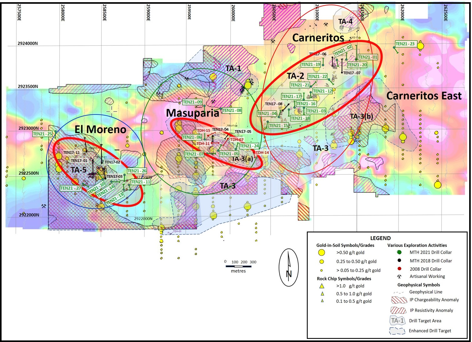
Click Image To View Full Size
Figure 2 – Drill Section, Drill Hole TEN 21-15 (looking east)
Click Image To View Full Size
Figure 3 – Drill Section, Drill Hole TEN 21-16 (looking east)

Click Image To View Full Size
Figure 4 – Drill Section, Drill Hole TEN 21-17 (looking east)
Click Image To View Full Size
Copyright (c) 2022 TheNewswire – All rights reserved.